Global Estimation of Water Resources Amount
- Assessment of global warming effect on global environment
- Making of sustainable water resources planning
- Estimation of global distribution of hydrological variables by pattern classification
Modeling of Water Cycle System in River Basin Scale
-
Proposal of new methodology in statistical hydrology and synthetic planning of water utilization
-
Short-term prediction of rainfall, snowfall, and slope collapse using digital weather radar system
-
Spatial and temporal distribution characteristics of abnormally low precipitation phenomena and their prediction
-
Downscaling of predicted values on climatic changes
-
Synthetic simulation modeling of a river basin and conservation of ecosystem in the river
Evaluation of Water Resources Systems with Various Scales
-
Analyses of values of water cycles
-
Proposal of recycling water usage system
-
Quantitative measurement of damage from drought
-
Development of System Dynamics approach to water resources system
Application of Artificial Intelligent Technology to Water Resources Management
- Knowledge-based decision support systems using Artificial Intelligent Technology for management of public facilities
- Application of multimedia to river basin management
Development of the land surface scheme (SiBUC)
LSS(Land-Surface Scheme) calculate the energy/water/radiation budget of the land surface to provide the lower boundary condition for the atmospheric model. The SiBUC (Simple Biosphere including Urban Canopy) model uses “mosaic” approach to incorporate all kind of land-use into LSS. In the SiBUC model, the surface of each grid area is divided into three landuse categories and five components.
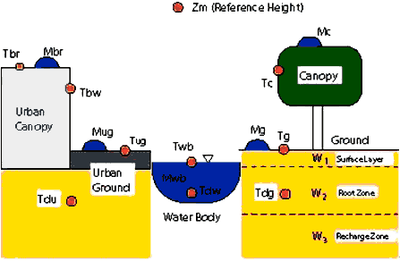
Figure: Schematic image of the land surface scheme (SiBUC). Model structure and prognostic variables are shown.
- green area (vegetation canopy, ground)
This is a natural land surface area (forest, grassland, bare soil, etc.), and it is usually treated in most LSS. For the vegetation scheme, SiB is adopted. Some modification from original SiB was done. - urban area (urban canopy, urban ground)
This is an artificial impermeable surface (buildings, houses, pavement, etc.). A new urban canopy scheme which can account for complex structure of canyon geometry has been developed. Heat island phenomena can be expressed by this scheme. - water body
This is a inland water surface (ponds, rivers, lakes) or ocean surface. Diurnal/seasonal variation of water temperature and evaporation is calculated depending on water depth.
Owing to the field experiments such as the Lake Biwa Project, GEWEX/GAME Project, paddy field and farmland irrigation/drainage scheme is developed. Which enables us to treat not only the natural water cycle, but also artificial water cycle caused by human activity.
Estimation of the global distribution of energy and water budget
The 2nd Global Soil Wetness Project (GSWP2) is an ongoing environmental modeling research activity initiated by the Global Energy and Water Cycle Experiment (GEWEX). One of the most important goal of GSWP2 is to produce state-of-the-art global data sets of land surface fluxes, state variables and related hydrological quantities for 10-year period (1986-1995). These data sets will be utilized to clarify the mechanism of climate variability and abnormal weather and role of land surface processes on them. In addition to the baseline experiment and sensitivity experiments of GSWP2, SiBUC is run with irrigation scheme activated to estimate the global distribution of irrigation water requirement (Figure-2). GSWP-2 homepage (http://grads.iges.org/gswp/)
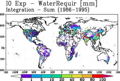
Figure: Global distribution of irrigation water requirement estimated by SiBUC